LAKE BONNEVILLE |
|
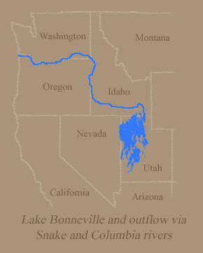
Imagine an ice-age lake in Utah whose surface area roughly equaled that of Lake Michigan. Also imagine that same ice-age lake releasing a surge of floodwater whose volume was six times the flood flow of the Mississippi River. Since no humans witnessed this event we can only picture it in our minds. But the lake and its destructive outflow were not someone's imaginary fantasies. Geologists know that it was all very real. After geologic processes millions of years ago created the unique basin-and-range topography of the western Rocky Mountains, an immense basin dominated the landscape of western Utah. Exactly when the body of water--later named Lake Bonneville--began to form in uncertain. The evidence indicates that it existed at least 600,000 years ago. As the climate became cooler and wetter Lake Bonneville expanded in size, gradually spreading over a surface area of about 20,000 square miles, and overlapping into Nevada and Idaho. Because Lake Bonneville was in a basin, it lacked natural outlets. Once captured, water from rainfall, stream flows, and glacial melting remained in the lake, except for those amounts lost through evaporation. At its greatest extent the lake level stood at 5,090 feet elevation--nearly 1,000 feet higher than the current level of Great Salt Lake. Distinct shorelines , including sand and gravel beaches, were formed along the 2,000 miles of Lake Bonneville's rim. Animals such as bears, camels, deer, mammoths, horses and musk oxen roamed its shores. In addition to being confined by higher ground at the basin rim, a "natural dam" at Lake Bonneville's northern limit at Red Rock Pass prevented outflows. The pass [south of Downey, Idaho, on U.S. 91] was the site of overlapping alluvial fans--huge deposits of rock, sand, and soil that had eroded during the weathering-down of nearby mountains.
|
|
THE CATACLYSMIC BONNEVILLE FLOOD |
|
| The breaching of the alluvial deposits at Red Rock Pass unleashed a torrent which ran about 300 feet in depth northward through the valleys of Marsh Creek and the Portneuf River and joined the Snake River near Pocatello, Idaho. The floodwaters followed the route of the Snake River and its existing canyons across southern Idaho, then veered north through Hell's Canyon, and finally poured into the Columbia River near Pasco, Washington. It is estimated that the initial flood volume, which persisted for perhaps two weeks, amounted to 15 million cubic feet per second--about 300 times the maximum flows ever recorded on the Snake River. Over a period of weeks and months nearly 1,000 cubic miles of water were released, and Lake Bonneville dropped more than 350 feet. The flood scoured the walls and bed of the Snake's existing canyons from Pocatello to Pasco, and also inundated a wide swath on the adjacent Snake River Plain across southern Idaho. The current cut deep recesses in the canyon walls and gouged holes in the canyon floor, creating waterfalls, alcoves and gravel bars. In Hell's Canyon the floodwaters left gravel bars along the river bends more than 100 feet above the modern river level. Deposits of sand and gravel also partially blocked Hell's Canyon's side valleys. The deluge then overwhelmed the Clearwater River at Lewiston, Idaho, and temporarily reversed its flow for several miles. [The flood is described more fully in David Alt and Donald W. Hyndman, Northwest Exposures: A Geologic Story of the Northwest.].
|
|
VISIBLE EVIDENCE |
|
| 6 | 7 |
THE AFTERMATH |
|
| 9 | |
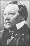
BENJAMIN L. E. BONNEVILLE |
|
| Lake Bonneville was named for Benjamin L. E. Bonneville, a French-born U.S. Army officer, who in the 1930s was involved in exploring and trading ventures in the Pacific Northwest. It is unlikely that Bonneville was even dimly aware of the existence of the former body of water that would later bear his name. A half-century later geologist G.K. Gilbert was the first to study these prehistoric lake features, and he decided to honor Captain Bonneville in this way.
|
|